The current extent of an Esri map can be retrieved as map parameters and used for subsequent filtering of map layers and reports. The extent can be in any coordinate system and must be a simple polygon.
The names of the map extent variables are:
- &MINX, which defines the minimum longitude of the extent.
- &MINY, which defines the minimum latitude of the extent.
- &MAXX, which defines the maximum longitude of the extent.
- &MAXY, which defines the maximum latitude of the extent.
Example: Using the Current Extent Parameters in a Map
The following steps create a map with a procedure that shows the markers within the current extent when the map is refreshed.
- Create a domain named RetailExtent.
- Right-click the domain, point to New, and click Procedure.
- Copy the following procedure, paste it into the text editor, and save it as retail_map.fex.
-DEFAULT &MINX=_FOC_NULL
-DEFAULT &MAXX=_FOC_NULL
-DEFAULT &MINY=_FOC_NULL
-DEFAULT &MAXY=_FOC_NULL

DEFINE FILE WF_RETAIL_LITE
LATITUDE = STATE_PROV_CAPITAL_LATITUDE;
LONGITUDE = STATE_PROV_CAPITAL_LONGITUDE;
END
TABLE FILE WF_RETAIL_LITE
PRINT
     ID_CUSTOMER
     QUANTITY_SOLD
     MSRP_US
     FST.LATITUDE
     FST.LONGITUDE

WHERE RECORDLIMIT EQ 250
WHERE COUNTRY_NAME EQ 'United States'
WHERE LATITUDE GE &MINY
WHERE LATITUDE LE &MAXY
WHERE LONGITUDE GE &MINX
WHERE LONGITUDE LE &MAXX
ON TABLE SET PAGE-NUM NOLEAD
ON TABLE SET ASNAMES ON
ON TABLE NOTOTAL
ON TABLE PCHOLD FORMAT XML
ON TABLE SET HTMLEMBEDIMG ON
ON TABLE SET HTMLCSS ON

END
This procedure uses WHERE selection tests to show the markers only for the extent that is displayed.
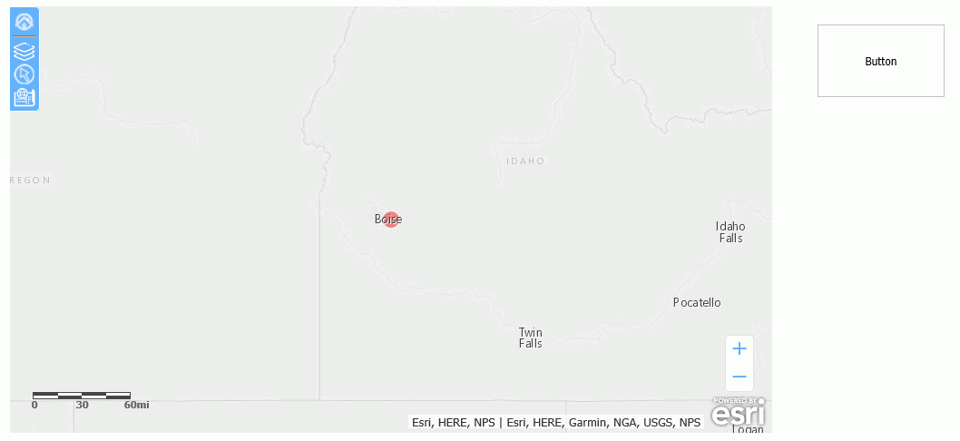
- Create a new HTML page and add a map object and a button, as shown in the following image.
- In the Requests & Data Sources panel, open the drop-down menu next to the New icon, point to External Request, and click WebFOCUS Procedure. Select retail_map.fex.
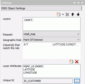
- Select the map and configure the Settings panel as shown in the following image.
- In the Requests & Data Sources panel, right-click the retail_map request
and select Create Controls for Parameters.
The New Parameters dialog box opens.
- Right-click the value in the first row of the Control Type column, point to Existing Control, and click emfobject1, as shown in the following image.
- Click OK.
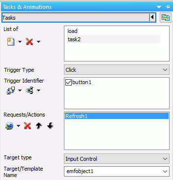
- Select the button and in the Tasks & Animations panel create a task that will refresh the map when the button is clicked,
as shown in the following image.
- Save the HTML page.
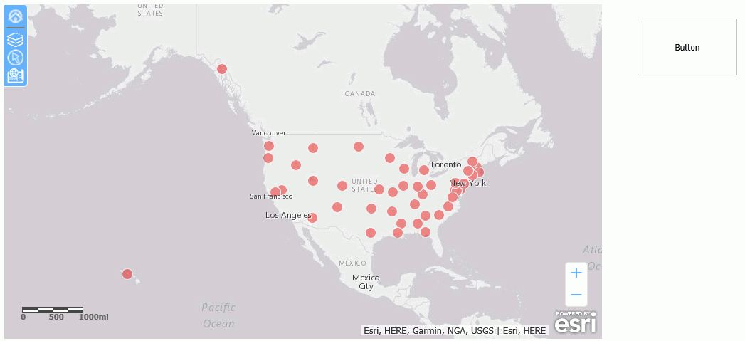
When you run the page, all of the markers are displayed on the map, as shown in the following image.
Zoom in and click the button. The map will be refreshed and only markers for that extent are displayed, as shown in the following image.