Syntax: How to Return a Geographic Component
GIS_REVERSE_COORDINATE(longitude, latitude, component)
where:
- longitude
-
Numeric
Is the longitude of the component to return.
- latitude
-
Numeric
Is the latitude of the component to return.
- component
-
Keyword
Is one of the following components:
- MATCH_ADDRESS, which returns the matching address.
- METROAREA, which returns the metro area name.
- REGION, which returns the region name.
- SUBREGION, which returns the subregion name.
- CITY, which returns the city name.
- POSTAL, which returns the postal code.
The value is returned as text and can be assigned to a field with text or alphanumeric (fixed or variable length) format.
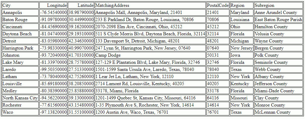
Example: Returning Geographic Components Associated With Coordinates
The following request uses city longitude and city latitude to return the matching address, postal code, region, and subregion.
TABLE FILE WF_RETAIL_GEOGRAPHY
SUM FST.CITY_LONGITUDE AS Longitude FST.CITY_LATITUDE AS Latitude
COMPUTE
MatchingAddress/A250 = GIS_REVERSE_COORDINATE(CITY_LONGITUDE,
                           CITY_LATITUDE, MATCH_ADDRESS);
PostalCode/A250 = GIS_REVERSE_COORDINATE(CITY_LONGITUDE,
                  CITY_LATITUDE, POSTAL);
Region/A250 = GIS_REVERSE_COORDINATE(CITY_LONGITUDE, CITY_LATITUDE,
              REGION);
Subregion/A250 = GIS_REVERSE_COORDINATE(CITY_LONGITUDE, CITY_LATITUDE,
                 SUBREGION);
BY CITY_NAME AS City
WHERE COUNTRY_NAME EQ 'United States'
WHERE TOTAL PostalCode NE ' '
WHERE RECORDLIMIT EQ 20
ON TABLE SET PAGE NOLEAD
END
The output is shown in the following image.