If any raster grid features are selected then a OpenSpirit grid event may be sent.
From the map view, if there are such features selected you may send a grid event by clicking on this button.
![]()
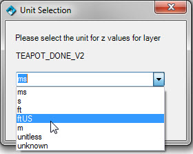
This will send a grid event containing the grid values. Before the grid event is sent you will be prompted to select a unit that describes the grid z values if the Always prompt for Z unit option is enabled.
The grid event will either be sent in the raster features CRS, or re-sampled and sent in the map display CRS. This choice is made in the OpenSpirit options dialog:
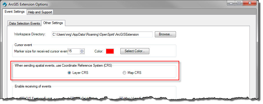
This options dialog is displayed by using this toolbar button:

If any grid is sent in a CRS with a datum other than WGS84 the OpenSpirit ArcGIS Extension will tag the grid CRS with a preferred transform to WGS84. The data is NOT transformed to WGS84 but this transform is included in the OpenSpirit event for the convenience of receiving applications that have asked OpenSpirit to deliver the spatial event in its project CRS (which may have a different datum). The OpenSpirit ArcGIS Extension will attempt to get the preferred transform by reading the transforms defined in the ArcMap project (as defined earlier by the user of the project). If no appropriate transform is found the user is prompted to select a transform from a list based on the EPSG database used by the OpenSpirit coordinate service (the details of the EPSG parameters may be shown in order to help guide this selection) :
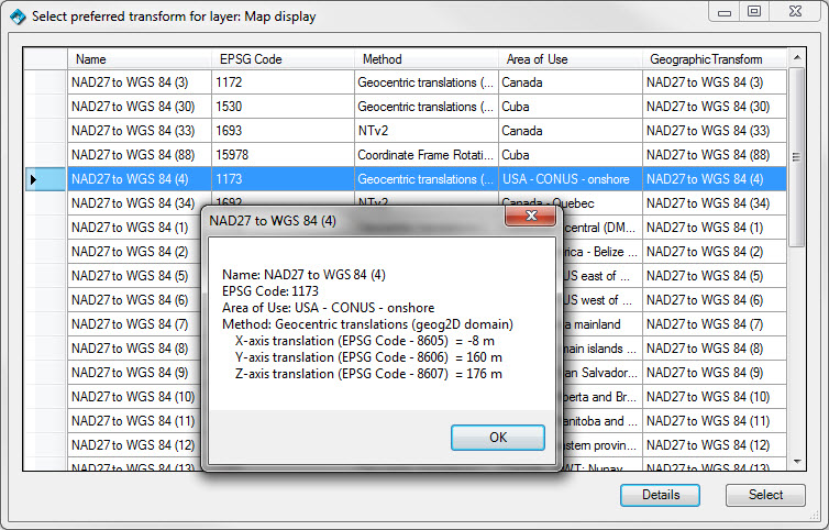
Any selected transforms are then added to the ArcMap project so the user does not need to repeat the same choice again.
![]() It is not necessary for the receiving application
to be running on the same PC as ArcGIS. It could be running on another
PC or on a Linux workstation. It must, however, be run under the same
account as the ArcGIS user (or an account registered as an OpenSpirit
secondary desktop for the ArcGIS user). The receiving application
must also be enabled for listening for grid
events.
It is not necessary for the receiving application
to be running on the same PC as ArcGIS. It could be running on another
PC or on a Linux workstation. It must, however, be run under the same
account as the ArcGIS user (or an account registered as an OpenSpirit
secondary desktop for the ArcGIS user). The receiving application
must also be enabled for listening for grid
events.
![]() A grid only has rectangular cells when used in the
CRS in which it was originally
calculated. Most G&G applications expect horizon grids to be
rectangular and will either not accept or will mishandle grids that
are not comprised of equal sized rectangular cells. For example,
if in ArcGIS you are displaying a DEM (Digital Elevation Model) that
is a rectangular grid in a geographic CRS
(e.g. WGS84) and you send an OpenSpirit grid
event (in the layer CRS)
most receiving applications (that work in a projected CRS)
would not be able to handle the nonlinear distortions in the grid. ArcGIS
has the capability , however, to resample and reproject grids on
the fly. So a ArcGIS user could set the map display CRS
in ArcGIS to equal that of the receiving application CRS
and then choose to send the grid event
in the map CRS. In this
case ArcGIS would resample and reproject the grid into the display CRS and then the OpenSpirit grid event would use this CRS and the receiving application would
receive a grid that was a regular rectangular grid in its projected CRS.
A grid only has rectangular cells when used in the
CRS in which it was originally
calculated. Most G&G applications expect horizon grids to be
rectangular and will either not accept or will mishandle grids that
are not comprised of equal sized rectangular cells. For example,
if in ArcGIS you are displaying a DEM (Digital Elevation Model) that
is a rectangular grid in a geographic CRS
(e.g. WGS84) and you send an OpenSpirit grid
event (in the layer CRS)
most receiving applications (that work in a projected CRS)
would not be able to handle the nonlinear distortions in the grid. ArcGIS
has the capability , however, to resample and reproject grids on
the fly. So a ArcGIS user could set the map display CRS
in ArcGIS to equal that of the receiving application CRS
and then choose to send the grid event
in the map CRS. In this
case ArcGIS would resample and reproject the grid into the display CRS and then the OpenSpirit grid event would use this CRS and the receiving application would
receive a grid that was a regular rectangular grid in its projected CRS.