This tab has four categories of settings. Click on the a category to jump down the page to the section describing it.
Click on the Restore to Defaults button to restore all of the General settings to their default values.
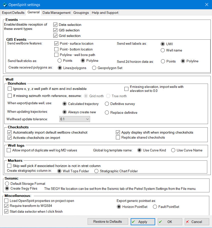
These checkboxes determine whether these types of events we be listened for. If a checkbox is not checked the corresponding event type will be ignored.
Enable checkboxes to determine which feature(s) will be sent when a wellbore is selected and a GIS event broadcast. Each feature type will be sent in a separate layer.
Choose whether to send Petrel fault polylines as point or polyline features. If sent as points to ArcGIS then the z values may be posted and symbolized by a variable color.
Choose whether to label the well GIS features that will be broadcast with the Petrel well UWI or its name.
Choose whether to send Petrel 2d seismic horizons as point or polyline features. If sent as points to ArcGIS then the z values may be posted and symbolized by a variable color.
Choose whether to create Lines/polygon objects or Geopolygon Set objects when receiving GIS events containing polygon layers.
If this checkbox is checked, the X, Y, Z wellbore trajectory values are not imported for wellbores that do have azimuth and inclination values. The X, Y, Z values will then be computed by Petrel. If this checkbox is not checked (the default), then X, Y, Z values are imported if available and any subsequent edits to the azimuth and inclination values on the imported wellbore will not be reflected in the X, Y, and Z values.
If this checkbox is not checked (the default) then wellbores that are missing an azimuth north reference for their deviation survey will not be imported. If checked then a missing north reference will be assumed to be either true north (line of longitude) or grid north (line of constant false Easting) based on the radio button choice.
If Calculated trajectory is selected the calculated borehole trajectory will be used. This is the data that appears in the borehole's spreadsheet in Petrel.
If Definitive survey is selected the survey control points will be used. This is the data that appears in the survey's spreadsheet in Petrel.
If Always create new is selected a new trajectory will be created for the Borehole and made the definitive survey.
If Replace definitive is selected a new trajectory will be created for the Borehole and made the definitive survey. If the Borehole already had a definitive survey it is removed.
This option is used to skip updating a well's wellhead location unless the distance between the current value and the new value is more than the tolerance. The tolerance values are distance expressed in the Petrel project's XY unit. Updating the wellhead is an expensive operation in Petrel, so this option can significantly improve performance when updating large numbers of wells.
If this checkbox is checked, wells with missing elevation will be imported, and their elevation will be set to kelly bushing with a value of 0.0.
If this checkbox is checked (the default) then the default (aka preferred) checkshot, if available, will automatically be imported when a wellbore is imported.
If this checkbox is not checked (the default) then checkshots will not get activated automatically upon import. They can be activated later by explicitly activating one or many in Petrel. If this checkbox is checked, then checkshots will be automatically activated upon import.
 Activating checkshots on import significantly increases the import time.
If this checkbox is checked (the default) then checkshot times that are to be imported will be shifted by the checkshot Display Shift times. Not all data stores have the concept of a display shift for checkshots (OpenWorks does...), but if the source data has a non-null display shift set and this checkbox is enabled then the time values of the time-depth pairs will be shifted by this amount.
Option to make a copy of a checkshot when an imported well checkshot is shared from another (see Checkshot Import Options for more details) . The default, box unchecked, does not replicate shared checkshots.
If this checkbox is checked, duplicate MD values will be slightly adjusted instead of being thrown away.
This option determines which OpenSpirit well log attribute is used for the well log name. Select Use Curve Kind to use the OpenSpirit log's Kind attribute for the log name. Select Use Curve Name to use the OpenSpirit log's Curve Name attribute for the log name.
If this checkbox is checked, well picks that are associated with a horizon will not be imported if a matching horizon name cannot be found in the well tops folder that the picks are imported into.
The existence of a stratigraphic chart containing matching horizons does
not allow well picks to be imported when the Skip
well pick if associated horizon is not in strat column option is
selected. You need to initialize the stratigraphy in the target well tops
folder using a stratigraphic chart prior to importing picks into the well
tops folder.
No picks will be imported if you enable the Skip
well pick if associated horizon is not in strat column option and
also have a grouping set for markers.
This option controls the way strat columns are imported. Select Well Tops Folder to import strat columns as well marker collections. Select Stratigraphic Chart Folder to import strat columns as a Stratigraphic Chart.
Choose this option to have imported 2D seismic data realized as Petrel RAW format in the Petrel project directory.
Choose this option to have imported 2D seismic data stored as Segy format. The Segy files are created in the default Petrel seismic directory which can be set using the Seismic tab on the Petrel System settings dialog available from the Petrel Tools menu.
This setting controls where Segy files are written when importing seismic data using the Create Segy Files option. Leave this setting blank to realize Segy files to the Petrel project folder. Select a file folder to realize the Segy files in a folder external to the Petrel project.
If checked then the OpenSpirit extended properties will be loaded when the Petrel project is opened. This then allows a user to see these properties in the Petrel object settings dialog without needing to first connect to OpenSpirit. For projects with many objects in it (especially well tops) this may significantly add to the project opening time. The default, box unchecked, is to delay restoring the extended properties until the connection to OpenSpirit is activated.
Uncheck this option to enable selecting a project coordinate system from the OpenSpirit EPSG list of coordinate systems without having to also select a datum shift to WGS84.
You may have problems sending and receiving GIS events and importing or
exporting spatial data if your project coordinate system does not have
a transform to WGS84.
Option to automatically start the OpenSpirit data Selector after the Project Initiation Wizard is finished or after connecting to OpenSpirit from an existing Petrel project. The OpenSpirit adapter will either use an existing or create a new OpenSpirit session called Petrel_ProjectName that has its CRS and units set to the Petrel project preferences.
This setting controls how generic Petrel pointset objects are exported. Select the Horizon PointSet option to export pointsets as horizons, select the Fault PointSet option to export pointsets as faults.