Adding a TMS layer

The Tile Map Service (TMS) is a widely supported map protocol. Use it to display a map background from a third party provider or to change the default map layer.

Prerequisites

To add a TMS layer, you must have a URL to a valid TMS map.
Tip: You can find many TMS resources on the internet. The article GeoAnalytics Resources on the TIBCO Spotfire Community site lists many TMS resources, both free and paid. The lists include the complete URL, copyright text, and if available, copyright URL to specify in the TMS layer. (The TIBCO Community site is free to use; however, you must register an account to gain access to the information.)

Procedure

  1. Right-click the map chart visualization, and from the menu, click Properties.
    The Properties popover is displayed, with the Map chart popover showing the current layers, in their layer order, top to bottom.
  2. Click Add new layer at the bottom of the Map chart list.
    A list of the layer options is displayed.
  3. From the list, click TMS layer.
    The TMS layer is added to the Map chart layer list, the Properties list for the layer is displayed, and the layer with its default settings is added to the map chart.
    Note: An error icon (error icon) is displayed in the title bar. (A TMS layer is not valid until the URL to a valid service is supplied.)
  4. Required: Provide the URL to a valid service.
    The error icon displayed in the title bar is no longer displayed.
    Note: The URL must be in the format http://base/url/{z}/{x}/{y}. {z} specifies zoom level, {x} specifies the column number, and {y} specifies the row number. You do not need to provide values for the three variables {z}/{x}/{y} for the map to work.
  5. Optional: Optionally, drag and drop the layer to a new position on the list.
  6. Review and set map chart properties to refine the display.
    Note that it is mandatory to include copyright information for the vast majority of third-party map providers. Open the Copyright section of the Properties popover to configure the copyright info.
    Tip: You can reuse the settings of an already existing layer. Select Duplicate layer in the Properties popover to duplicate either the selected layer in the same map chart, or to add a copy of a layer from another map chart in the analysis. See Duplicating a layer for detailed instructions.

TMS layer example

In this example, the map chart has a feature layer displaying the outlines of Australia counties on top of a TMS layer.

  • The feature layer for Australia Counties is available in the geocoding data tables provided in the library. The transparency is set to a high degree to show outline and shading. The feature layer is the top layer of the map chart.
  • The standard map layer is removed. The TMS layer replaces the standard map.
  • The TMS layer is drawn from a map from OpenStreetMap, so the Title property is set to OpenStreetMap.
  • The URL is set to http://a.tile.openstreetmap.org/{z}/{x}/{y}.png.
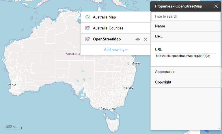

TMS map layer