Adding a Custom Basemap
The list of basemaps available to InfoAssist is built dynamically on the server using the list of <basemap> objects in the geo_services.xml file, which is located in the catalog directory under the server home directory:
_edahome/catalog/
Note: Optionally, on the Reporting Server, you can show this directory on the application tree by clicking Show edahome, edaconf, edaprfu, scaroot, edatemp, edalog and foccache for all users on the Filter menu of the Reporting Server Console Applications page. You can then edit the geo_services.xml file directly in the Reporting Server Console.
Following are some sample standard basemap definitions from this file that exist prior to customization.
<BASEMAPS>
...
 <basemap custom="false" default="false" name="streets"
    title="World Street Map" icon="qb/streets_map_108x72.png" />
 <basemap custom="false" default="false" name="satellite"
    title="World Imagery" icon="qb/imagery_map_108x72.png" />
 <basemap custom="false" default="false" name="terrain"
    title="Terrain with Labels" icon="qb/terrain_map_108x72.png" />
 <basemap custom="false" default="true" name="gray"
    title="Light Gray Canvas Map" icon="qb/gray_map_108x72.png" />
...
</BASEMAPS>
The properties defined for the standard basemaps are custom (which is false for the standard basemaps), default, name, title, and icon.
To define a custom basemap, you must define these properties for your custom basemap, and add a URL that points to the map service that has the basemap image.
Note: Any basemap you add must be a tiled map layer.
You can also customize the list of basemaps by deleting basemap definitions from the <basemaps> object. To configure Esri on Premise, you should remove any basemap definition that references a URL that points to a location outside of your locally hosted Esri server.
The syntax for a basemap definition is
<basemap custom="boolean" default="boolean" name="mapname"
  title="maptitle" icon="url_to_icon" url="url_to_basemap"
/>
where:
- custom="boolean"
-
Specifies whether the basemap is standard or custom. Valid values are true and false. To add a custom basemap, specify custom="true".
- default="boolean"
-
Specifies whether this basemap should be the default basemap if the user does not select a basemap. Valid values are true and false.
- name="mapname"
-
Is a name for the basemap.
- title="maptitle"
-
Is a title that will display in the Basemap drop-down list in the list of basemaps in InfoAssist.
- icon="url_to_icon"
-
Is the location of a thumbnail image for the basemap.
- url="url_to_basemap"
-
Is the URL to the map service that provides the basemap.
After you add the basemap definition, you can run the geo_srv_basemaps procedure to see if the parameters were added correctly.
Example: Adding a Custom Basemap
The following <basemap> object defines the soil survey basemap.
<basemap name="soil_survey" custom="true" default="false" title="Soil_Survey_Basemap"
icon="https://server.arcgisonline.com/arcgis/rest/services/Specialty/Soil_Survey_Map/MapServer/info/thumbnail"
url="https://server.arcgisonline.com/ArcGIS/rest/services/Specialty/Soil_Survey_Map/MapServer" />
Add this definition to the list of basemap objects in the geo_services.xml file. Note that the entire URL string must be on one line in the file, even if it breaks in this document because of the page size.
Optionally, on the Reporting Server, run the geo_srv_basemaps procedure. The output is shown in the following image.

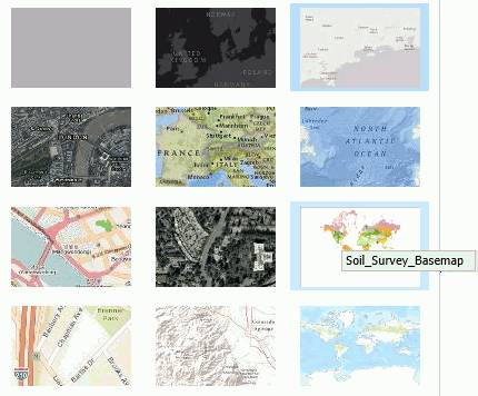
When you create a map, your custom basemap appears in the Basemap drop-down list in InfoAssist, as shown in the following image.

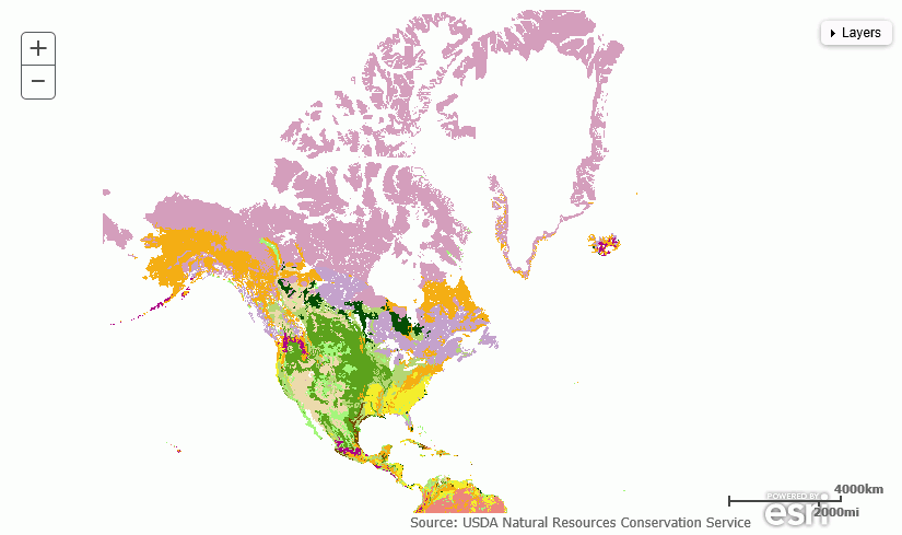
The following image shows the map output using the soil survey basemap.
