Reference: |
In addition to configuring standard Esri map services, the Reporting Server hosts and configures geographic boundaries for 58 World Administrative regions, out of the box. With a second level map license, you have access to additional detailed postal codes.
You can use these files to generate Esri maps in WebFOCUS App Studio. To support using these administrative boundaries in maps that can show geographic locations down to the postal code level, the list of geographic roles has been simplified and unified.
The server provides a Geographic Configuration Editor tool for uploading and configuring additional shapefiles and geographic roles, basemaps, and demographic layers. For information, see Configuring Geographic Information.
The list of geographic roles has been simplified and unified by adding hierarchical levels of keys in the server geographic configuration file. Your request that provides the geography dimension must provide the hierarchical keys needed to identify each target geography. For example, if your geographic role is City, you must also provide values for State and Country.
The following is the list of unified geographic roles is available for generating maps:
Note: WebFOCUS App Studio does not support aliasing or name variations in geographic roles. Users have to cleanse the data and provide the right values for all the georoles. Only Names are supported.
The following request, city1.fex, retrieves world city names, state names, and country names.
TABLE FILE wf_retail_lite SUM COGS_US REVENUE_US FST.CITY_NAME BY COUNTRY_NAME BY STATE_PROV_NAME ON TABLE PCHOLD FORMAT XML END
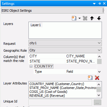
The following Settings panel for the HTML page that will generate the map is shown in the following image. CITY_NAME is the field that matches the geographic role. The keys needed to correctly identify each city are State (STATE_PROV_NAME field) and Country (COUNTRY_NAME field).
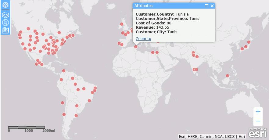
Running the HTML page generates the following map.
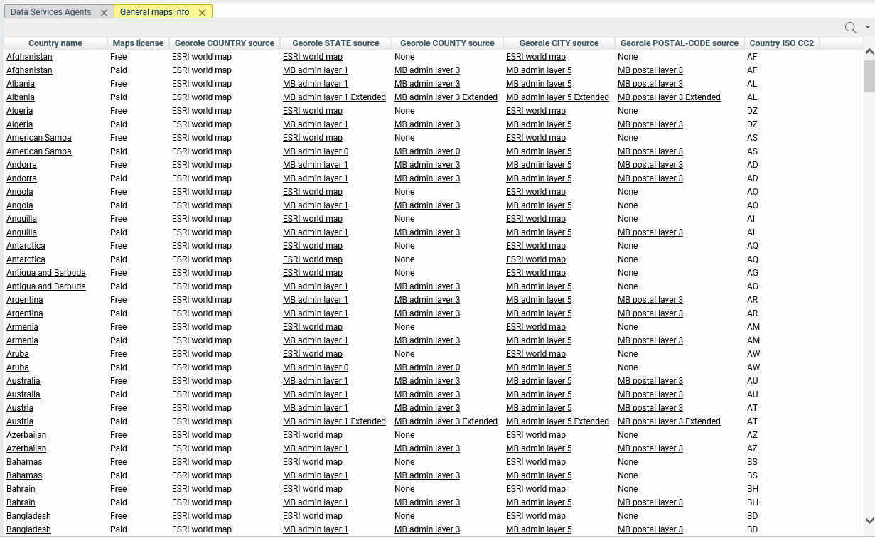
The Reporting Server browser interface provides a list of first and second level map administrative regions. You can open the list by clicking Geo Services on the Workspace page ribbon and selecting General maps info. This opens the list of administrative regions and postal levels, as shown in the following image.
The regions that say Paid in the Maps license column are the additional regions you can access with a second level license.
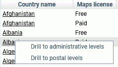
Some georoles may not be applicable to specific countries. You can see the details of each country and its administrative levels by right-clicking the country name and clicking Drill to administrative levels or Drill to postal levels, as shown in the following image.
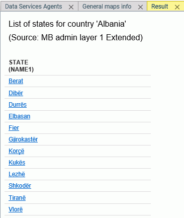
Clicking Drill to administrative levels opens the list of States for the country, as shown in the following image.
Clicking any link opens information about the next level georole.
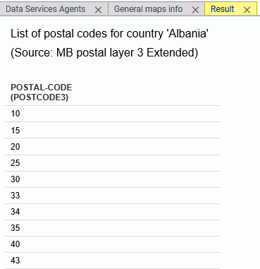
Clicking Drill to postal levels opens the list of postal levels for the country, as shown in the following image.
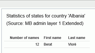
Right-clicking a link in any georole column other than the Country column opens a summary of the values for that georole, as shown in the following image.
Administrative boundaries for the United States are automatically included by Esri.
The following table lists the Level 1 countries and their Level 1 and Level 2 administrative levels. For some countries, no additional administrative levels are added with a second level license.
Country |
Postal Code |
Level 1 Administrative Level (Number of Values) |
Level 2 Administrative Level (Number of Values) |
---|---|---|---|
Albania |
2 - digit |
Qarke (12) |
Bashkia (61) |
Andorra |
5 - digit |
Parroquies (7) |
|
Argentina |
5 - digit |
Departamentos (525) |
|
Australia |
4 - digit |
Local Government Areas (569) |
|
Austria |
4 - digit |
Gemeinden (2120) |
|
Belarus |
6 - digit |
Woblaszi (7) |
Raioni (129) |
Belgium |
4 - digit |
Communes (589) |
|
Bosnia and Herzegovina |
5 - digit |
Kantone (18) |
Opstine (142) |
Brazil |
5 - digit |
Municipios (5565) |
|
Canada |
3 - digit |
Census Divisions (293) |
Census Subdivisions (5243) |
Chile |
2 - digit |
Provincias (54) |
|
China |
2 - digit |
Counties City Districts (2855) |
|
Costa Rica |
2 - digit |
Cantones (81) |
Distritos (473) |
Croatia |
2 - digit 5-digit for 2nd level license |
Zupanije (21) |
Opcine (556) |
Cyprus |
2 - digit 4-digit for 2nd level license |
Eparchia (6) |
Dimoi (615) |
Czech Republic |
2 - digit 6-digit for 2nd level license |
Orp (206) |
Obce (6253) |
Denmark |
4 - digit |
Kommuner (99) |
|
Estonia |
5 - digit |
Maakonnad (15) |
Vallad (213) |
Finland |
5 - digit |
Seutukunnat (70) |
Kunnat (317) |
France |
5 - digit |
Cantons (1972) |
Communes (36571) |
Germany |
5 - digit |
Municipilaties |
|
Gibraltar |
3/4/5 - digit |
||
Greece |
5 - digit |
Nomoi (75) |
Dimoi (326) |
Holy See (Vatican City State) |
5 - digit |
||
Hong Kong |
6 - digit |
Shih Zizhiqu (18) |
|
Hungary |
2 - digit 4-digit for 2nd level license |
Kistersegek (175) |
Telepulesek (3177) |
Iceland |
2 - digit 3-digit for 2nd level license |
Landsvaedi (8) |
Sveitarfelog (74) |
India |
6 - digit |
Districts (640) |
Subdistricts (5783) |
Italy |
5 - digit |
Provincias (110) |
Comuni (8047) |
Japan |
3 - digit |
Prefectures (47) |
Municipalities (1901) |
Kenya |
1 - digit |
Wilaya (47) |
Districts (158) |
Korea, Republic of |
3 - digit |
Si Gun (230) |
|
Latvia |
2 - digit 4-digit for 2nd level license |
Rajons (33) |
Novadi (119) |
Liechtenstein |
4 - digit |
Landschaften (2) |
Gemeinden (11) |
Lithuania |
2 - digit 5-digit for 2nd level license |
Apskritys (10) |
Savivaldybes (60) |
Luxembourg |
4 - digit |
Cantons (12) |
Communes (105) |
Macedonia, the former Yugoslav Republic of |
2 - digit 4-digit for 2nd level license |
Statisticki Regioni (8) |
Opstini (80) |
Malta |
3 - digit |
Districts (6) |
Local Councils (68) |
Mexico |
3 - digit |
Estados (32) |
|
Monaco |
5 - digit |
Quartiers (9) |
|
Montenegro |
2 - digit 5-digit for 2nd level license |
Opstina (21) |
|
Netherlands |
4 - digit |
Gemeenten (380) |
|
New Zealand |
4 - digit |
Territorial Authorities (68) |
Area Units (1911) |
Norway |
4 - digit |
Okonomisk regioner (89) |
Kommuner (428) |
Poland |
5 - digit |
Gminy (2479) |
Gminy Miasta (3119) |
Portugal |
4 - digit |
Concelhos (308) |
Freguesias (3092) |
San Marino |
5 - digit |
Castelli (9) |
|
Serbia |
5 - digit 5-digit (1156) for 2nd level license |
National (1) |
|
Singapore |
2 - digit |
Regions (5) |
Planning Areas (55) |
Slovakia |
2 - digit 6-digit for 2nd level license |
Okresy (79) |
Obce (2927) |
Slovenia |
2 - digit 4-digit for 2nd level license |
Statisticne Regije (12) |
Obcina (212) |
South Africa |
2-digit 4-digit for 2nd level license |
Municipalities (234) |
|
Spain |
5 - digit |
Provincias (52) |
Municipios (8122) |
Sweden |
5 - digit |
Kommuner (290) |
|
Switzerland |
4 - digit |
Gemeinden (2225) |
|
Taiwan |
3 - digit |
Township Districts (368) |
|
Turkey |
5 - digit |
Iller (81) |
Ilceler (970) |
United Kingdom |
4 - digit |
Districts (391) |
The following table lists countries that are accessible only with a second level license.
Country |
Postal Code |
Highest Administrative Level (Number of Values) |
Lowest Administrative Level (Number of Values) |
---|---|---|---|
Afghanistan |
4-digit |
Velayat (34) |
Woluswali (398) |
Algeria |
2-digit |
Wilayat (48) |
|
American Samoa |
5-digit |
Counties (77) |
|
Angola |
Provincias (18) |
Municipios (161) |
|
Anguilla |
7-digit |
Districts (14) |
|
Antigua and Barbuda |
Parishes (8) |
||
Armenia |
2-digit |
Marzer (11) |
|
Aruba |
Districts (8) |
||
Azerbaijan |
2-digit |
Regions (10) |
Rayonlar (74) |
Bahamas |
Islands (19) |
Districts (32) |
|
Bahrain |
2-digit |
Muhafazat (5) |
|
Bangladesh |
2-digit |
Zila (64) |
Upazila (553) |
Barbados |
Parishes (11) |
||
Belize |
Districts (6) |
Constituencies (31) |
|
Benin |
Departements (12) |
Communes (77) |
|
Bermuda |
4-digit |
Parishes (11) |
|
Bhutan |
2-digit |
Dzongkhags (20) |
|
Bolivia, Plurinational State of |
Departamentos (9) |
Provincias (112) |
|
Botswana |
Districts (9) |
Sub-Districts (28) |
|
British Virgin Islands |
National (1) |
Electoral Districts (9) |
|
Brunei Darussalam |
2-digit |
Daerah (4) |
Mukim (38) |
Burkina Faso |
Regions (13) |
Provinces (45) |
|
Burundi |
Provinces (17) |
Communes (129) |
|
Cambodia |
Khaet (25) |
||
Cameroon |
Regions (10) |
Departements (58) |
|
Cape Verde |
2-digit |
Concelhos (22) |
Freguesias (32) |
Cayman Islands |
8-digit |
Districts (6) |
|
Central African Republic |
Prefectures (17) |
Sous-Prefectures (51) |
|
Chad |
National (1) |
||
Colombia |
2-digit |
Departamentos (33) |
Municipios (1122) |
Comoros |
Islands (3) |
||
Congo |
Departements (12) |
||
Congo, the Democratic Republic of the |
Districts (48) |
Territoires (188) |
|
Côte d'Ivoire |
Regions (32) |
Departements (95) |
|
Cuba |
Provincias (16) |
Municipios (168) |
|
Djibouti |
Regions (6) |
||
Dominica |
Parishes (10) |
||
Dominican Republic |
5-digit |
Provincias (32) |
Municipios (155) |
Ecuador |
6 - digit |
Cantones (224) |
Parroquias (1040) |
Egypt |
2-digit |
States (27) |
|
El Salvador |
7-digit |
Departamentos (14) |
Municipios (262) |
Equatorial Guinea |
Regions (2) |
Provinces (7) |
|
Eritrea |
Zobas (6) |
Subzobas (52) |
|
Ethiopia |
Kililoch (11) |
Awrajja (85) |
|
Faroe Islands |
3 - digit |
Syslur (6) |
Kommunur (30) |
Fiji |
Provinces (15) |
||
French Guiana |
5-digit |
Cantons (14) |
Communes (22) |
French Polynesia |
5-digit |
Iles (5) |
Communes (48) |
French Southern Territories |
Districts (4) |
||
Gabon |
Provinces (9) |
||
Gambia |
Local Government Areas (8) |
||
Georgia |
Regions (12) |
Rajone (77) |
|
Ghana |
Regions (10) |
Districts (216) |
|
Greenland |
4-digit |
Kommuner (6) |
|
Grenada |
Parishes (7) |
||
Guadeloupe |
5-digit |
Cantons (28) |
Communes (32) |
Guam |
5-digit |
County Subdivisions (19) |
|
Guatemala |
5-digit |
Departamentos (22) |
Municipios (334) |
Guernsey |
5-digit |
Parishes (15) |
|
Guinea |
Regions (8) |
Prefectures (34) |
|
Guinea-Bissau |
4-digit |
Regioes (9) |
Sectores (38) |
Guyana |
Regions (10) |
||
Haiti |
Arrondissements (42) |
Communes (140) |
|
Honduras |
2-digit |
Departamentos (18) |
Municipios (298) |
Indonesia |
3-digit |
States (34) |
|
Iran, Islamic Republic of |
1-digit |
Provinces (31) |
Subprovinces (397) |
Iraq |
Muhafazat (18) |
Kaza (109) |
|
Ireland |
Counties (34) |
Electoral Divisions (3441) |
|
Isle of Man |
5-digit |
Sheadings (6) |
Districts (24) |
Israel |
2-digit |
States (6) |
|
Jamaica |
Parishes (14) |
Constituencies (62) |
|
Jersey |
5-digit |
Parishes (12) |
|
Jordan |
5-digit |
Muhafazat (12) |
Nahia (51) |
Kazakhstan |
4-digit |
Oblystar (16) |
Audandar (209) |
Korea, Democratic People's Republic of |
Do (14) |
||
Kosovo |
2-digit |
Obstina (38) |
|
Kuwait |
2-digit |
Muhafazat (6) |
Localities (137) |
Kyrgyzstan |
4-digit |
Oblasttar (9) |
Rajondor (46) |
Lao People's Democratic Republic |
Khoueng (17) |
Muang (142) |
|
Lebanon |
Muhafazat (6) |
Caza (26) |
|
Lesotho |
Districts (10) |
||
Liberia |
Counties (15) |
||
Libyan Arab Jamahiriya |
Schabiyat (22) |
||
Macao |
6-digit |
Parishes (8) |
|
Madagascar |
3-digit |
Regions (22) |
Districts (114) |
Malawi |
Regions (3) |
Districts (30) |
|
Malaysia |
2-digit |
Negeri (16) |
Daerah (144) |
Maldives |
2-digit |
Atolls (20) |
|
Mali |
Regions (9) |
Cercles (50) |
|
Marshall Islands |
3-digit |
Municipalities (34) |
|
Martinique |
5-digit |
Arrondissements (4) |
Communes (34) |
Mauritania |
Wilayas (13) |
Moughataas (53) |
|
Mauritius |
Districts (10) |
||
Mayotte |
Communes (17) |
||
Micronesia, Federated States of |
5-digit |
States (4) |
|
Moldova, Republic of |
4-digit |
Raioane (37) |
|
Mongolia |
4-digit |
Aimags (22) |
Sums (338) |
Montserrat |
Parishes (3) |
||
Morocco |
2-digit |
Regions (16) |
Provinces (75) |
Mozambique |
2-digit |
Provincias (11) |
Distritos (142) |
Myanmar |
States and Divisions (15) |
||
Namibia |
Regions (13) |
Constituencies (119) |
|
Nauru |
Districts (14) |
||
Nepal |
Zones (14) |
Districts (75) |
|
New Caledonia |
5-digit |
Provinces (3) |
Communes (34) |
Nicaragua |
Departamentos (17) |
Municipios (153) |
|
Niger |
Regions (8) |
||
Nigeria |
States (37) |
Local Government Areas (774) |
|
Northern Mariana Islands |
5-digit |
Municipalities (4) |
|
Oman |
1-digit |
Muhafazat (11) |
Wilayat (61) |
Pakistan |
2-digit |
Provinces (8) |
Districts (146) |
Palau |
5-digit |
States (16) |
|
Palestinian Territory, Occupied |
Territories (2) |
Muhafazat (16) |
|
Panama |
Provincias (12) |
Distritos (76) |
|
Papua New Guinea |
Provinces (22) |
Districts (87) |
|
Paraguay |
Departamentos (18) |
Distritos (251) |
|
Peru |
2 - digit |
Provincias (195) |
Distritos (1834) |
Philippines |
4-digit |
Provinces (87) |
Municipalities and Cities (1634) |
Pitcairn |
8-digit |
Islands (4) |
|
Puerto Rico |
5-digit |
Municipios (78) |
County Subdivisions (902) |
Qatar |
Municipalities (7) |
Zones (90) |
|
Republic of South Sudan |
States (10) |
||
Réunion |
5-digit |
Arrondissements (4) |
Communes (24) |
Romania |
6 - digit |
Judete (42) |
Comune (3181) |
Russian Federation |
4-digit |
Federal Subjects (80) |
Raioni (2345) |
Rwanda |
Provinces (5) |
Districts (30) |
|
Saint Kitts and Nevis |
States (2) |
Parishes (14) |
|
Saint Lucia |
Quarters (10) |
||
Saint Vincent and the Grenadines |
4-digit |
Parishes (6) |
|
Samoa |
3-digit |
Regions (4) |
Districts (43) |
Sao Tome and Principe |
Province (2) |
Distritos (7) |
|
Saudi Arabia |
2-digit |
States (13) |
|
Senegal |
Regions (14) |
||
Seychelles |
Districts (25) |
||
Sierra Leone |
Provinces (4) |
Districts (14) |
|
Solomon Islands |
Provinces (10) |
||
South Sudan |
2-digit |
States (10) |
|
Sri Lanka |
2-digit |
Districts (25) |
DS-Divisions (331) |
Sudan |
2-digit |
States (15) |
|
Suriname |
Districten (10) |
Ressorten (62) |
|
Svalbard and Jan Mayen (IE) |
Counties (34) |
Electoral Divisions (3441) |
|
Svalbard and Jan Mayen (SJ) |
4-digit |
National (1) |
Kommuner (4) |
Swaziland |
1-digit |
Districts (4) |
|
Syrian Arab Republic |
Muhafazat (14) |
Manatiq (61) |
|
Tajikistan |
Regions (5) |
Raioni (64) |
|
Tanzania, United Republic of |
Mkoa (30) |
Wilayah (169) |
|
Thailand |
2-digit |
Changwate (77) |
Amphoe (928) |
Timor-Leste |
Districts (13) |
Subdistricts (65) |
|
Togo |
Regions (5) |
||
Tokelau |
Atolls (3) |
||
Tonga |
Island Divisions (5) |
||
Trinidad and Tobago |
Municipalities (15) |
||
Tunisia |
4-digit |
Wilayat (24) |
|
Turkmenistan |
3-digit |
Welayaty (6) |
Etraplar (65) |
Turks and Caicos Islands |
8-digit |
Districts (6) |
Localities (38) |
Tuvalu |
Islands (9) |
||
Uganda |
Consolidated Districts (75) |
Counties (110) |
|
Ukraine |
3-digit |
Obstina (38) |
|
United Arab Emirates |
States (7) |
||
United States Minor Outlying Islands |
Islands (5) |
||
United States Virgin Islands |
5-digit |
National (1) |
Islands (3) |
Uruguay |
5 - digit |
Secciones (232) |
Segmentos (4301) |
Uzbekistan |
4-digit |
Viloyati (14) |
Tuman (171) |
Vanuatu |
Provinces (6) |
||
Venezuela, Bolivarian Republic of |
2 - digit |
Estados (25) |
Municipios (367) |
Viet Nam |
2 - digit |
Provinces (63) |
Districts (698) |
Wallis and Futuna |
5 - digit |
Kingdoms (3) |
|
Yemen |
Muhafazat (21) |
Muderiah (333) |
|
Zambia |
5 - digit |
Provinces (10) |
Districts (103) |
Zimbabwe |
Provinces (10) |
Districts (91) |
The request used in this example references data about French state names, city names, and postal codes. This data is readily available online. The data in this example was downloaded from https://www.aggdata.com/free/france-postal-codes which is available for free using a Creative Commons Attribution 4.0 license detailed at https://creativecommons.org/licenses/by/4.0/. Once you download the data, you can upload it to the server to create the data file and synonym for use in requests. This example assumes that the data and synonym are in the ibisamp application on the server.
Note: TIBCO takes no responsibility for the accuracy or continued existence of this data on this site. It is being used only as an example of the detailed administrative boundaries available with a second level license.
The Master File for the uploaded data follows. The Master File generated by the upload procedure was edited to change the first field name to COUNTRY and to remove the folder declarations.
FILENAME=FR_POSTAL_CODES, SUFFIX=DFIX , DATASET=ibisamp/fr_postal_codes.ftm (LRECL 1140 RECFM V, BV_NAMESPACE=OFF, $ SEGMENT=FR_POSTAL_CODES, SEGTYPE=S0, $ FIELDNAME=COUNTRY, ALIAS=E01, USAGE=A50V, ACTUAL=A50V, TITLE='Country for State', GEOGRAPHIC_ROLE=COUNTRY, $ FIELDNAME=STATE, ALIAS=E02, USAGE=A21V, ACTUAL=A21V, MISSING=ON, TITLE='State', GEOGRAPHIC_ROLE=STATE, $ FIELDNAME=COUNTY, ALIAS=E03, USAGE=A25V, ACTUAL=A25V, MISSING=ON, TITLE='County', GEOGRAPHIC_ROLE=COUNTY, $ FIELDNAME=CITY, ALIAS=E04, USAGE=A48V, ACTUAL=A48V, MISSING=ON, TITLE='City', GEOGRAPHIC_ROLE=CITY, $ FIELDNAME=POSTAL_CODE, ALIAS=E05, USAGE=A16V, ACTUAL=A16V, MISSING=ON, TITLE='Postal Code', GEOGRAPHIC_ROLE=POSTAL-CODE, $ FIELDNAME=PLACE_NAME, ALIAS=E06, USAGE=A56V, ACTUAL=A56V, MISSING=ON, TITLE='Place Name', $ FIELDNAME=GEO_POINT, ALIAS=E07, USAGE=A150, ACTUAL=A150, TITLE='GIS Point', GEOGRAPHIC_ROLE=GEOMETRY_POINT, $
The Access File for the uploaded data follows.
SEGNAME=FR_POSTAL_CODES, DELIMITER=',', CDN=COMMAS_DOT, CONNECTION=<local>, $
The following request named frenchzip2.fex creates the xml file with the postal code data that is passed to the HTML page with the Esri component.
TABLE FILE ibisamp/fr_postal_codes PRINT COUNTRY STATE CITY POSTAL_CODE ON TABLE PCHOLD FORMAT XML END
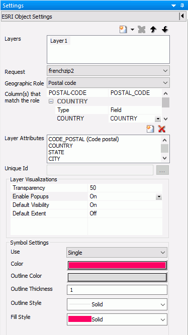
Configure the Server with a second level license. Create an HTML page, add an Esri component, and select the frenchzip2 request in the Requests & Data Sources panel. Then configure the Settings panel to use the request and the Postal code geographic role, as shown in the following image.
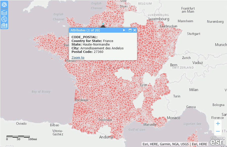
Run the HTML page. The output is shown in the following image, with one of the postal codes clicked to display the popup.
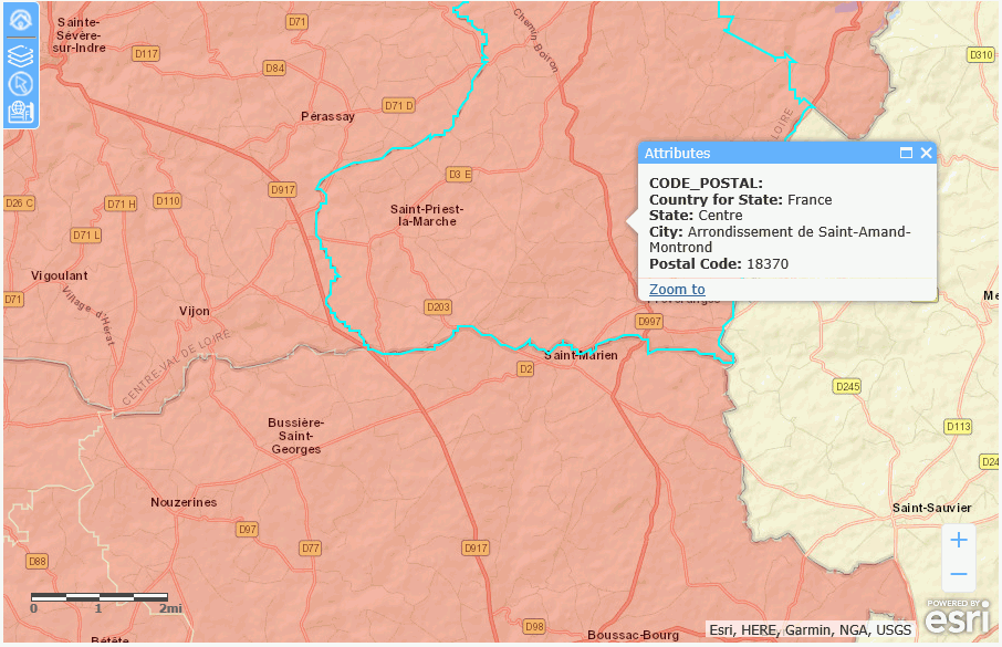
You can zoom in to see the boundaries of individual postal codes and change to a basemap that shows more detail, such as the World Street Map, as shown in the following image (the layer transparency has also been changed to 30% using the Table of Contents widget, in order to see the background detail more clearly).