Showing directions using marker rotation in a map chart
Some marker shapes, for example arrows, indicate directions. If you, in a map chart marker layer, rotate such markers, you can visualize directions of motions. What you need is a column that contains values that can be interpreted as degrees.
The rotation of the markers can be made clockwise or counter-clockwise. A full rotation is 360 degrees, and a value of 361 is interpreted as 1 degree.
Procedure
Map chart marker layer showing wind direction
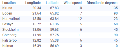
The data table below lists wind speed and wind direction, for a number of locations. The wind directions are expressed in degrees.
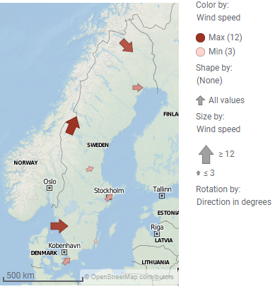
The markers in the marker layer below are used to visualize the direction of the wind at each location (and the marker sizes reflect the wind speed).
If the selected marker shape is
 , then, a 90 degree clockwise rotation of this marker shape will be displayed as
 . If you instead select
 as the marker shape to use, a 90 degree clockwise rotation would be displayed as
 .
.
How many degrees each marker should be rotated is defined by the 'Direction in degrees' data column. The rotation direction in this example is set to clockwise.


