OpenSpirit
Data Selector Tab Name |
Screen
shot from Petrel Input Tree |
Petrel
Object Type Created |
Comments |
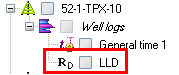
| Well
group |
Well |
 |
Well |
When
a wellbore selection is received a Petrel well is created and
if the source wellbore has a preferred checkshot this is also
imported and set as the active checkshot on the Petrel well (and
a General time log created). Wellbores that are missing a well
reference datum (e.g. a KB elevation) are not imported (unless
you have selected the option to assume 0.0 for the datum) and
wellbores missing an azimuth north reference are also skipped
(unless you have set a default north reference in the OpenSpirit
settings dialog). Skipped data is noted in the log file.
A
new survey is created and made the definitive survey for imports
that are an overwrite of a matching borehole. Existing surveys
are not updated. |
Pick |
 |
Well
Tops |
Well
picks are imported one of two ways based on the Skip
well pick if associated horizon is not in strat column setting
and the existence of matching horizon names in the well tops stratigraphy
folder.
Well picks are imported
as follows if the Skip well
pick if associated horizon is not in strat column setting
is not enabled.
A new top level well tops folder named
"Well Tops 1" is
created in the Petrel Input tree if there is not already a well
tops folder in the input tree. A new horizon and zone entry is
made in the stratigraphy folder for every unique well pick name.
Well picks that have an associated horizon are ordered by the
geologic age of their associated horizon. |
 |
Well
picks are imported as follows if the Skip
well pick if associated horizon is not in strat column
setting
is enabled and the selected well tops folder contains horizons
in its stratigraphy folder.
Well picks that have
an associated horizon that matches the name of a horizon in the
well tops stratigraphy folder are imported into the well tops
folder. Well picks that do not have an associated horizon that
matches the name of a horizon in the well tops stratigraphy folder
are not imported. No modifications are made to the horizons and
zones in the well tops folder.
 Consider
importing the strat column that defines the stratigraphy of the
picks that you want to import prior to importing the picks. The
strat column can be imported as a well tops folder which can then
be used as the selected well tops folder when importing picks. Consider
importing the strat column that defines the stratigraphy of the
picks that you want to import prior to importing the picks. The
strat column can be imported as a well tops folder which can then
be used as the selected well tops folder when importing picks. |
| Log |
 |
Well
Log |
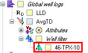
The
OpenSpirit log kind is used to find the corresponding Petrel log
template and an entry made in the Global logs section. If multiple
versions of the same log kind are added to the same well, a number
is appended to the log kind name to distinguish them. Duplicate
measured depth values will be discarded unless you have selected
the option to allow the import of duplicates. |
| Checkshot |
 |
Checkshot |
The
preferred checkshot is automatically imported when a well is created
via OpenSpirit. You may also send additional checkshots. A user
must then select which to use as the active checkshot. If the
checkshot datum differs from the Petrel SRD
then you are prompted to either supply a replacement velocity
(to be used to shift the checkshot times) or to skip importing
the checkshot. |
| Strat
Column |
 |
Strat
Column |
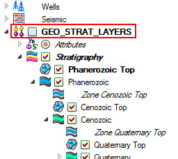
Strat
columns are imported in one of two ways based on the Create
stratigraphic column in setting.
Strat columns are imported
as follows if the Create
stratigraphic column in setting is set to Well Tops Folder.
A new top level well
tops folder is created in the Petrel Input tree for each strat
column that is being imported. Each top level well tops folder
is given the name of the strat column it will contain. A hierarchical
stratigraphy is created under the well tops folder to represent
the strat column. A hierarchy of top, zone, and base horizon is
created for all strat units defined in the strat column. |
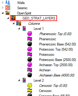 |
Strat
columns are imported as follows if the Create
stratigraphic column in setting is set to Stratigraphic Chart Folder.
A new top level stratigraphic
chart folder named OpenSpirit
is
created if one does not already exist in the Petrel input tree.
A stratigraphic chart folder is then created under the
OpenSpirit folder
for each stratigraphic column that is imported. Petrel stratigraphic
columns are created for each level of strat unit contained in
the strat column. Stratigraphic events are created for the top
and base horizon of each strat unit. |
| Seismic
group |
| 3D
Survey |
 |
Survey |
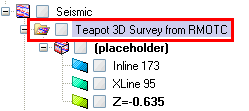
If
a 3d survey event is received a Survey Folder is created and a
dummy 3d seismic volume placed in it (called "(placeholder)"
-
this is required because a 3d survey may not be created in Petrel
without an associated seismic volume). A Survey folder
is automatically created, if needed, when a 3d volume is received. |
| 3D Volume |
 |
3D
seismic |
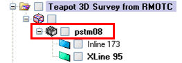
A "dummy"
unlabeled cube is made and a virtual attribute cube is placed
under it which is a live-link to
the remote seismic volume. A zgy file may then be created by realizing
the volume or a subset of it. If a seismic time volume's
datum differs from the Petrel SRD
then you are prompted to either supply a replacement velocity
(to be used to shift the start time) or to skip importing the
volume.
Live
links can be realized in a background task using the Live-link
Manager. |
| 2D
Survey |
 |
Survey |
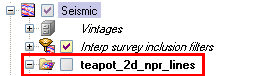
If
a 2d survey event is received a Survey Folder is created. A
Survey folder is also automatically created, if needed, when a
2D line or 2D Dataset is received. |
| 2D
Navigation |
 |
2d
seismic |
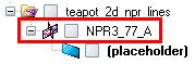
If
a 2d line event is received a 2d Line Folder is created (if needed)
and a dummy 2d seismic line placed in it (called
"(placeholder)" - this
is required because a 2d line may not be created in Petrel without
an associated seismic dataset). A Line folder is also
created, if needed, when a 2d dataset is received. By
default, the data is saved into SEGY format, unless you select
the option to save into Petrel’s RAW format. |
| 2D
Dataset |
 |
2d
seismic |
If
a seismic time dataset's datum differs from the Petrel SRD then you are prompted to either supply a
replacement velocity (to be used to shift the start time) or to
skip importing the dataset. |
| 3D
Seismic Horizon group |
| 3D
Horizon |
 |
3D
Interpretation grid |
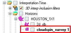
If
a horizon selection from a 3d survey is received then a
3d interpretation grid is made and placed under the corresponding
Petrel seismic horizon name (which is created if it doesn't already
exist). The 3d interpretation grid is named after its 3d survey.
Only the elevation property is initially brought in (either
time or depth based on the horizon's domain) .
If a seismic time horizon's
datum differs from the Petrel SRD
then you are prompted to either supply a replacement velocity
(to be used to shift the times) or to skip importing the horizon. |
| Horizon
Properties |
 |
Continuous
attribute |
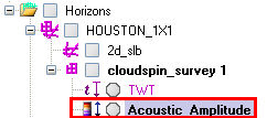
When
a horizon property event is received and there is no corresponding
3D interpretation grid already in Petrel then the 3d interpretation
grid will automatically be created so that the property may be
attached to it.
If the horizon's domain
is time, Z will be set to 0. If domain is depth, Z will
be set to Petrel project SRD. |
| Horizon
Fault Boundaries |
 |
Lines/polygons |
|
| 2D
Seismic Horizon group |
| 2D
Horizon |
 |
2D
Interpretation |
When
a horizon selection from a 2d seismic interpretation is received
a 2d interpretation is made and placed under the corresponding
Petrel seismic horizon name (which is created if it doesn't already
exist). The 2d interpretation is named after its 2d survey.
If a seismic time horizon's
datum differs from the Petrel SRD
then you are prompted to either supply a replacement velocity
(to be used to shift the times) or to skip importing the horizon. |
| Non-seismic
Horizon group |
| Grid |
 |
Surface |
When
a non-seismic horizon selection is received a Petrel surface
will be created. If the grid is not rectangular (in
the Petrel project CRS) it will
not be imported |
| Point Set |
 |
Points |
Received
horizon PointSets are placed in a folder named "Surfaces
-Time" or "Surfaces-Depth"
-
based on domain. |
| Point Set Properties |
 |
Points |
Received
horizon PointSetProperties are placed in a folder named "Surfaces
-Time" or "Surfaces-Depth"
-
based on domain. The properties are placed under the PointSet
that they are associated with. |
| Fault
group |
| Fault
(type= PolylineSet) |
 |
Fault
interpretation |
|
| Fault
(type= PointSet) |
 |
Points |
Received
fault PointSets are placed in a folder named "Faults
-Time" or "Faults-Depth"
-
based on domain. |
| Fault
(type= PointSetProperty) |
 |
Points |
Received
fault PointSetProperties are placed in a folder named "Faults
-Time" or "Faults-Depth"
-
based on domain. The properties are placed under the PointSet
that they are associated with. |
| Culture
group |
| Point
Feature |
 |
Points |
Creates
a feature whose name comes from the feature column that is called
"name" or has "name" in it. If no such column
exists the featureid is used as the Petrel object name. Automatically
imports all associated Point Feature attributes with Point features |
| Polyline
Feature |
 |
Lines/polygons |
Creates
a feature whose name comes from the feature column that is called
"name" or has "name" in it. If no such column
exists the featureid is used as the Petrel object name. Automatically
imports all associated Polyline Feature attributes with Polyline
features |
| Polygon
Feature |
 |
Lines/polygons |
Creates
a feature whose name comes from the feature column that is called
"name" or has "name" in it. If no such column
exists the featureid is used as the Petrel object name. Automatically
imports all associated Polygon Feature attributes with Polygon
features |
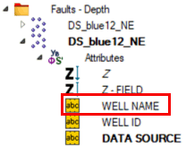
If data is imported via this
mechanism the Petrel objects that are created are "tagged" with
the OpenSpirit datakey and the last modified date from the source data
store. This will allow synchronization with the external data source.
In addition, based on settings in the configuration file, additional attributes,
beyond what is mappable to the Petrel data model, will be added to the
Petrel object. These extended attributes may be viewed in the Settings
dialog of any imported object in the OpenSpirit Properties tab (as illustrated
below).
When data is imported entries
are made in the Petrel object history to document from where the data
was imported and what assumptions may have been made during import (see
example below).