Geographic location and geocoding
To display data on a map, the data must either be geocoded or directly contain coordinates such as longitude or latitude. Geocoding in Spotfire means that some identifiers in a data table are used to match against similar identifiers in another set of data tables (a geocoding hierarchy) which contains latitude/longitude coordinates or geographic features. These coordinates or features are then used for correctly positioning the data in a map context. If your data contains simple geographic elements such as country names, states, or similar, then Spotfire will attempt to automatically geocode your data. If no automatic geocoding can be performed, you can set up the geocoding manually instead.
By specifying that a column in a data table should be used to match against a specific geocoding hierarchy you can make the process of setting up a map chart with that data easier.
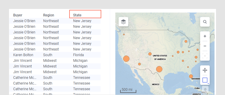
In this example, the state column is automatically identified as US States and the data is correctly positioned on the map.
Automatic geocoding and hierarchies
A geocoding hierarchy is a collection of ordered geocoding tables that can give you the opportunity to drill down to a more detailed level when zooming in on the data. The hierarchy should contain all geocoding tables that the layer should be allowed to choose from when applying geocoding, and it should preferably be a geographic hierarchy with different level of detail, such as:
- Table 1: US States (a table containing state geometries identified by state names (and/or codes).
- Table 2: US Counties (a table containing county geometries identified by the full state/county hierarchy).
Spotfire automatically adds (hidden) geocoding data tables if you add a map chart for a data table where geographical names can be found. When selecting the best suited geocoding table, Spotfire checks the expression on the Geocode by/Marker by or Feature by-axis and chooses the geocoding table to which the geocoding primary key columns can be matched using column matching. If only State is used on the axis, the US States table would be selected, but if both State and County are used on the axis, then the US Counties table is selected.
Once Spotfire has chosen a geocoding table, the visualization downloads and joins in that table in the map chart based on the found column matches.
Manual geocoding
When you are manually setting up geocoding you must consider which columns in your data can be used to identify the location of the data. For example, this could be a State column or a State/County hierarchy. Note that the level at which you select to display your data is the one that should be used for geocoding, since the Marker by axis and the Geocoding by axis in map charts are the same in marker layers. Hence, if you want to show data for different states you must geocode by state and not by counties.
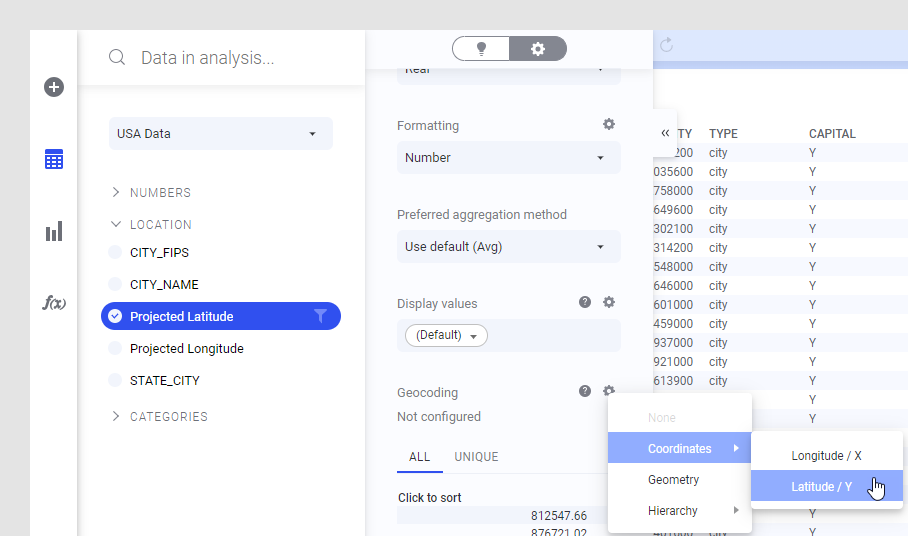
You can specify the geocoding type and representation for a selected column in your analysis by clicking on the column in the Data in analysis flyout and, in the Details on selected column view of the expanded flyout, choosing a suitable Geocoding property or hierarchy. You can easily specify that a column contains either longitude or latitude values, geometries, or some hierarchical location. See also Specifying new geocoding tables.
You can also try using the Auto-match option (available under Hierarchy in the Geocoding settings) to try to match on the content of the column rather than on the column name, if you know that your data contains common locations but the column names in the data table do not match any of the columns in the available geocoding tables.
Geocoding hierarchies in the library
A set of default geocoding hierarchies is shipped with Spotfire Server as a zip archive which a library administrator can import into the library. Each hierarchy consists of a number of geocoding tables. Once imported, the geocoding hierarchies are normally located in the GeoAnalytics folder in the library. Because most of these geocoding tables contain geographic shapes, they can also be used as feature layers in your map chart. The geocoding hierarchies located in the library will show up in the list when you choose to add a new marker layer of feature layer in a map chart.
Disabling automatic geocoding in an on-premises environment
A Spotfire on-premises Administrator can disable auto-loading of
geocoding tables completely for a group of users by setting the
AutoloadGeocodingTables preference to
False. This preference is found in the installed
client by selecting
. Go to the
Preferences tab, and look in the
MapChartPreferences group to locate the preference.
This can be desired if the group is on a slow connection or if the system repeatedly makes unwanted geocoding matchings.