Click Files
and data ![]() .
.
In the Files and data flyout, select Spotfire library.
Right-click the library item of interest.
From the menu that opens, select Edit properties.
This dialog is used to edit the properties for an item in the library. This tab is only applicable for SBDF data files saved in the library, and only of interest if the data contains some type of geographic information which can be used to position data on a map.
To reach the Edit Properties dialog:
Click Files
and data ![]() .
.
In the Files and data flyout, select Spotfire library.
Right-click the library item of interest.
From the menu that opens, select Edit properties.
In the Library Administration tool, you can reach the dialog by clicking on the Edit link for the Selected Item.
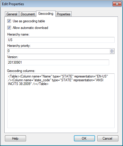
Option |
Description |
Use
as geocoding table |
Allows you to specify that a table should/may be used as a geocoding table. |
Allow
automatic download |
Specifies that the data may be automatically downloaded to be used for geocoding other data tables. Clear the check box for large data tables to avoid large files from being automatically downloaded. If geocoding tables are not automatically downloaded they may still be added at a later stage from the Positioning or Geocoding page for the map chart layer in question. |
Hierarchy
name |
The name of the geocoding hierarchy the data table belongs to. |
Hierarchy
priority |
The priority of the hierarchy. If more than one hierarchy can be used for geographical matching, then the hierarchy with the highest priority is used for automatic matching. |
Version |
The version (date) of the data table, specified in the format YYYYMMDD. |
Geocoding
columns |
Lists a read-only representation of the geocoding columns included in the data. The geocoding properties may be set on the columns in Spotfire prior to exporting the data file to the library. |
See also:
Saving an Analysis File in the Library
Editing Properties in the Library Administration tool
Details on Edit Properties – General